How to Decode EMWIN Data (Via VHF Rebroadcast) With an SDR

To preface this article, I didn’t know EMWIN existed until I finally one day posted a signal sample on the Signal Identification Wiki of a peculiarly very strong buzz saw sounding signal at approximately 163.37 Mhz. Soon thereafter, some helpful people cross referenced the frequency with my location (Which I completely overlooked doing…shame on me) and discovered that it was in fact a VHF re-transmission of an EMWIN signal. Ok, so that’s part of the mystery solved, but what is it? It turns out EMWIN is an acronym that stands For Emergency Managers Weather Information Network. The EMWIN datastream is broadcast by the National Oceanic and Atmospheric Administration over the GOES geostationary weather satellites at around 1692.7 MHz (according to goes-r.gov) to provide individuals with real time and (relatively) fast weather information for critical decision making. With coordination between a few local agencies, a VHF rebroadcast of the signal can be set up apparently, and many repeaters are still transmitting to this day, 24/7. After searching for hours on Google and finding little information about how to decode the information, I finally figured it out on my own and want to write this tutorial for anyone else who is interested or has been struggling like I was since there is so little information out there on this transmission scheme.
What it is
EMWIN provides text weather forecasts in plain 8-bit ASCII which is in a human readable format. Additionally, there are graphical products transmitted such as national RADAR which are transmitted over the same modulation scheme, but use the NWS Universal Transmission Format (UTF) encoding. Unfortunately, I cannot find any (at least moderately modern) software that allows for decoding of the graphical products via sound card or RTL-SDR, but fortunately, the specifications are open to the public on the NOAA website for EMWIN. Hopefully with these specs and some programming knowledge, I can create a decoder program to display the graphical products nicely in the near future. I will be working on this and will post updates as progress is being made.
Ok then, for now lets get on to decoding! The VHF rebroadcast in my area (Northern IL) is on approximately 163.370 Mhz. For hardware I am using an RTL-SDR.com blog v3 dongle and SDR# for Windows. I am also using VB-Cable as a loopback sound device.
Setup
Hopefully you already have SDR# set up, but if you don’t, there are plenty of guides that will help you since I will not get into great detail here. Make sure after installing VB-Cable that you set the output soundcard to its input in SDR#’s audio menu. Also make sure that under the audio tab you have “Filter Audio” unchecked, this is very important! Next up is to tune to the stream’s frequency. I am not entirely sure where else to find if there is a rebroadcast in your area other than scanning the 160-165 Mhz range either manually or looking at whats licensed to TX in your area at those frequencies with a site such as RadioReference.com. As I said before, the frequency near me is 163.370 Mhz. Make sure you are in Narrowband FM demodulation mode (NFM button in SDR#) and you should be hearing the lovely ear piercing sound of good ol’ 1200 baud ASCII. Below is a small audio clip of what it should sound like.
Decoding
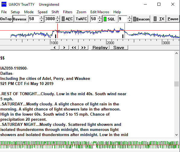
To decode the ASCII data, I am using a free program called TrueTTY, though I’m sure any other program that can decode 1200 baud 8-bit ASCII will work. After getting and installing it or opening your favorite demodulation program, first make sure the selected soundcard is the VB Cable option as that’s what our NFM demodulated audio is being sent on. Next, set the mode in TrueTTY (or your favorite multi-mode decoder) to ASCII-8. Next, set the frequency shift to 1Khz (1000Hz) and finally, set the speed to 1200 baud. For me in TrueTTY I also had to click the Normal/Reverse signal frequency button (Similar to reversing the mark and space frequencies of RTTY). Now if you are tuned in to the EMWIN frequency and set up correctly, you should start seeing weather related text! Congratulations!